
September 13, 2021
10:30 pm CST Update
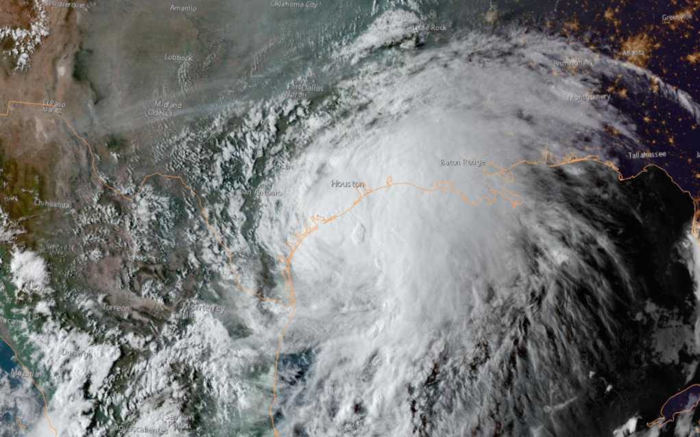
The National Hurricane Center has upgraded Nicholas to a minimum hurricane. Maximum sustained winds have increased to near 75 miles per hour with higher wind gusts. A Hurricane Warning is now in effect from Port O’Connor to Freeport. This will not change the ongoing or forecast impacts whatsoever. Storm surge will continue to cause flooding along with the Middle and Upper Texas Coast.
3:00 pm CST Update
Local OEM agencies and the National Hurricane Center are recommending all residents shelter in place as of 6:00 pm CST.
Again, as stated previously, if your home floods please stay home as this will be the safest place. If water rises, do not go into your attic as you can be trapped and risk drowning. Do not walk, swim or play in flood waters. Debris, wildlife, and other dangers can cause serious injury or even death.
2:00 pm CST Update
Fort Bend Co. Levee Improvement District No. 7 (FBCLID 7) would like residents to know they are monitoring the development of Tropical Storm Nicholas in conjunction with the District Operator. Based on current forecasts from the National Hurricane Center, Nicholas is expected to make landfall somewhere between Corpus Christi and Galveston Bay this evening.

Heavy rainfall of up to 3 to 4 inches per hour is expected to move into our area. Street flooding and rises along rivers, streams, and bayous are likely. Tropical storm force winds are also likely along the coast and into portions of Harris, Fort Bend and Colorado Counties. High winds can arrive as early as 2 p.m. today. For information on bayou conditions, visit Harris County Flood Control's Flood Warning System website.
Residents are encouraged to take the time now to check their yard and secure any loose items. Once heavy rain arrives, please stay indoors and off the roads. Remember, only call 911 in an emergency as first responders will be stretched thin during this weather event.
A flash flood watch is in effect for areas along and southeast of US 59. If your home floods, please stay home as this will be the safest place. If water rises, do not go into your attic as you can be trapped and risk drowning. Do not walk, swim or play in flood waters. Debris, wildlife, and other dangers can cause serious injury or even death.

Monitor local media and other trusted sources for weather and other information often over the next several days.
If you must drive, slow down and leave additional space between you and other vehicles. NEVER drive your vehicle through flooded roadways. Turn Around Don't Drown! Check the Houston TranStar live traffic map for information on road conditions and flooded main lanes in the region.
The good news is FBCLID 7 facilities have been very dry and the drainage and storm sewer systems are empty. All drainage facilities are able to handle full capacity of storm water, pump stations and supplemental pumps are fully operational should they be needed.
Here are some ways that you can assist and encourage your system to drain as efficiently as possible:
- Bring in any trash cans, bags or other items that could get caught in rising street water. These items can float and block the inlet preventing or restricting any water from entering the storm drains.
- If you typically have a car parked in the street, consider pulling it up into your driveway as close to your house as possible, with the engine towards the house. If unable to pull the car into the driveway, consider asking a neighbor to use any unoccupied space.
- Be sure to monitor official announcements from Fort Bend County Office of Emergency Management (https://fbcoem.org/) and the National Weather Service (https://www.weather.gov/) for official updates.
This article will be updated as further developments occur. For questions on this update or otherwise related to the District, please use the website Contact Us page.
Would your neighbors benefit from this information? Share it to social media! Click the "Share" button above to share it to Facebook or Twitter, or copy the link for sharing to Nextdoor or via email.